


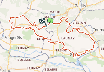
13.04.2019 corrigé - La Gacilly sud à Glénac

babeth35
User

Length
28 km

Max alt
89 m

Uphill gradient
459 m
Km-Effort
34 km

Min alt
3 m

Downhill gradient
461 m
Boucle
Yes
Creation date :
2019-04-15 16:59:13.184
Updated on :
2020-07-20 14:57:47.951
7h26
Difficulty : Medium

FREE GPS app for hiking
 SityTrail
IGN / Geographical institutes
SityTrail Plus
The world is yours!
About
Trail Walking of 28 km to be discovered at Brittany, Morbihan, Les Fougerêts. This trail is proposed by babeth35.
Photos


Positioning
Country:
France
Region :
Brittany
Department/Province :
Morbihan
Municipality :
Les Fougerêts
Location:
Unknown
Start:(Dec)
Start:(UTM)
562285 ; 5288665 (30T) N.
Comments